If you work with heightfields...
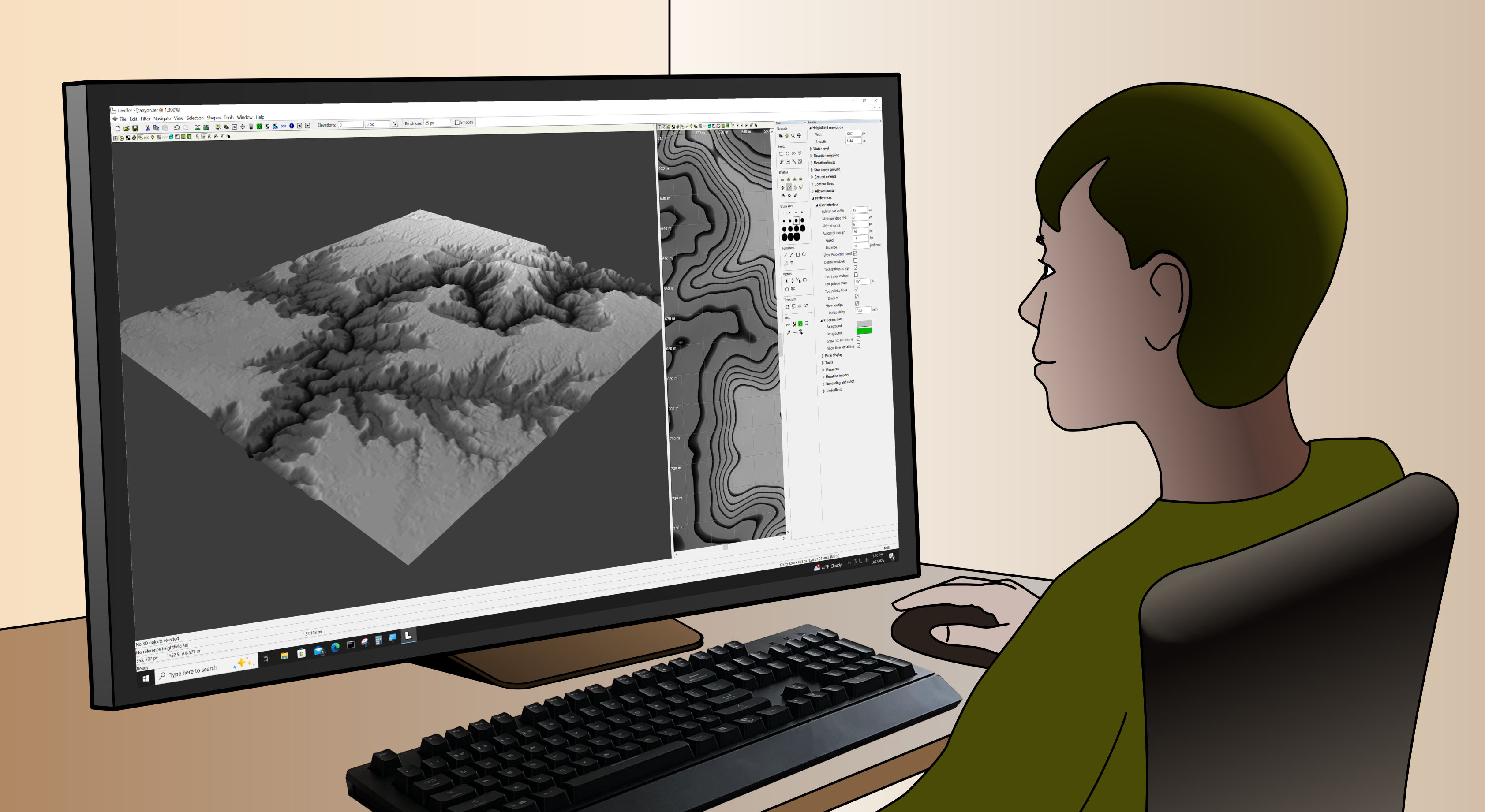
Leveller, the powerful and friendly heightmap modeler
Intuitive 3D sandbox sculpting with the accuracy of georeferencing, vector shapes,
32-bit pixel precision and 16-bit selection masking.
Leveller's affordable, easy to use, and gets your elevation data where it needs to be.
More information available here.
Available for Microsoft Windows 7 or higher.
WinTab-based graphics tablets supported (e.g. Wacom).
“Excellent tool!”
— Lynn Grant, educational software developer
Features
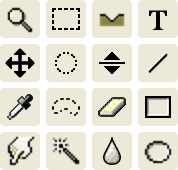
A familiar environment
Use tools that you already know from paint and illustration software. The digital sandbox paradigm lets you sculpt in a freeform, natural way.
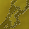
Selection masking
Select any arbitrary set of heightfield pixels to limit and focus any modeling operation. Select by shape, by brushing, by searching for neighbouring elevations and colors, by loading from grayscale files, etc.
Custom brushes
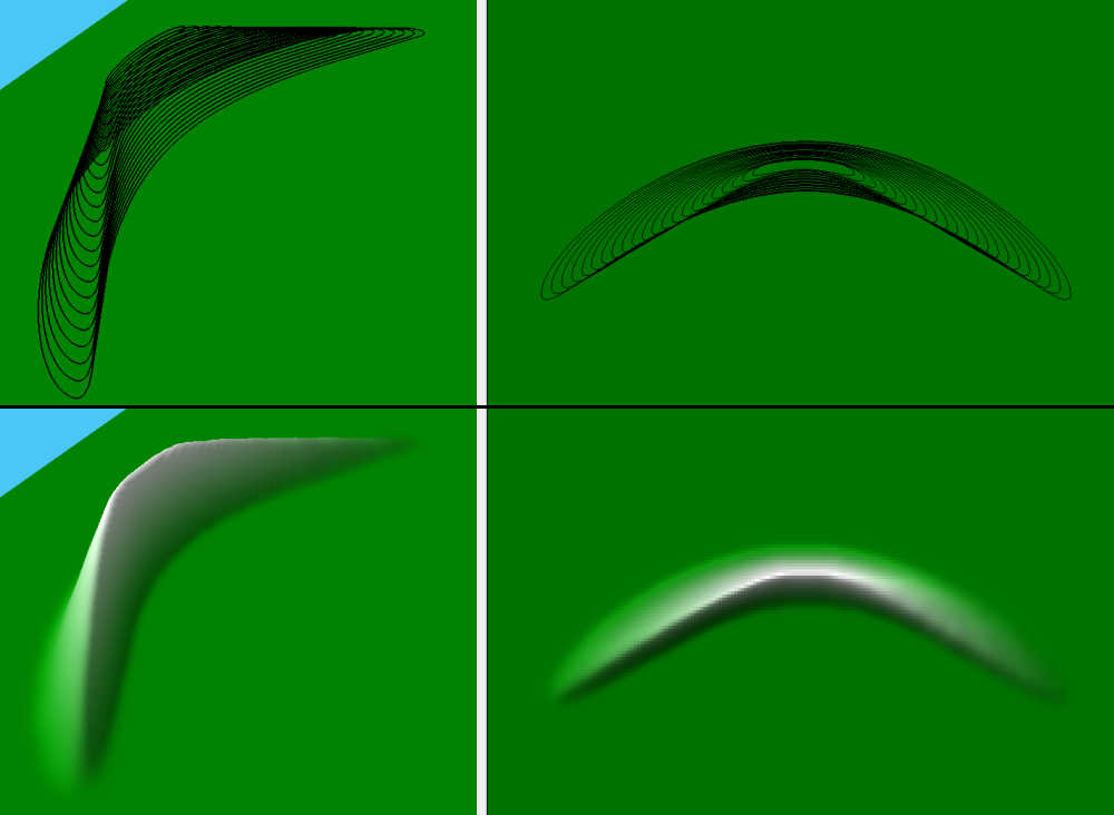
Unleash your creativity. Define your own brushes to make unlimited stroke patterns. Stroke vector shape paths for precise brushing and overlapping. Make temporary tweaks to brushes on the fly to stay in the zone; create new brushes only when necessary. Tutorial
Flexible measurement
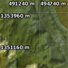
Work with realworld coordinates such as UTM or latitude/longitude, or use a custom local coordinate system. Use different measurement units for ground and altitude. Specify slopes in degrees or percentages.
Filters and generators
Create and modify terrain using a variety of effects, from the basic to the very handy to the imaginative. Lakes, craters, hills, random and regular patterns, erosion... all sorts of heavy lifting just a few clicks away.
Flyover animations
Create motion paths for the camera and the look-at point, then generate frames using OpenGL or raytracing. Store any number of paths using the vector shape facility.
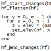
Scripting
Create filter and selector plug-ins and macros using Lua. Specify UI dialogs using simple XML. Access often-used commands and macros using the powerful Favorite Commands feature.
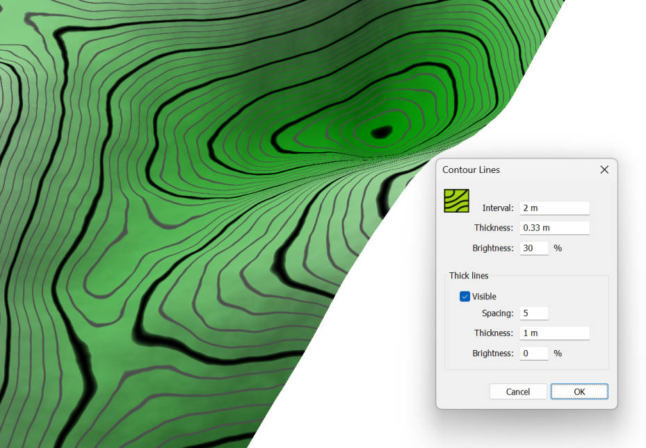
Contour lines + elevation labels
Keep track of terrain elevations easily with contour lines that redraw in realtime, as you edit. Place elevation labels where you want.
Slope and curvature maps
Visualize slope-dependant colorations such as snow, golf green speed, etc. Easily define your own slope color tables. Curvature maps (second order derivative) let you see where slope changes greatly over short distances.
Contour import/export + creation
Directly read in contour data from DXF polyline files, ESRI shapefiles, or from Adobe Illustrator gray-filled paths, and export to DXF. You can also create contour lines from raster terrain and vice versa.
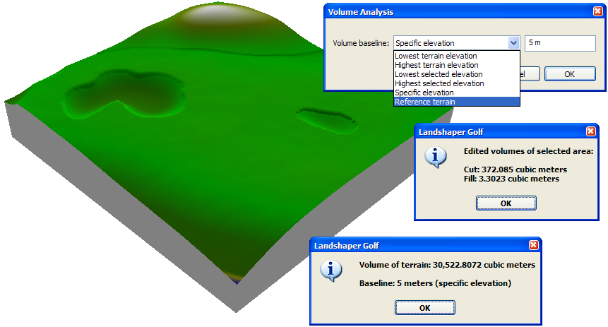
Cut/fill volume analysis
Track differences between new and old terrain automatically, with statusbar readouts showing total cut and fill volumes and relative colormaps highlighting the location of edits. Assess volumes for selected subregions too. Generate detailed per-area reports in CSV format.
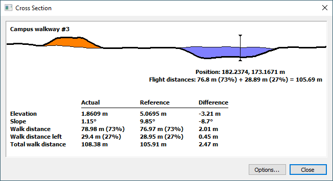
Cross section analysis
Display cross sections along any vector shape's path, and query any point along a cross section for details, including cut/fill data.
Graphics tablet support
Gain a natural drawing feel. Apply a light touch to create subtle lifts and depressions or a heavy one to quickly push elevations around. Customize pressure sensitivity mappings individually for each tool.
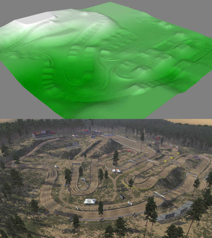
Motocross Track Design
Leveller excels at modeling terrain for motocross game maps. It's used by professional track makers worldwide and developed with their input. The exquisite level of control lets you maximize track playability. Berms, ruts, ramps, rollers... Leveller has you covered.
"Leveller has been a game changer for me in motocross track building—it's way easier to pick up than I thought it'd be compared to other tools. The features are super handy for crafting every part of my tracks just the way I want them. Even though I've only been at it for a few months, I'm all in, using it a ton and really digging the top-notch support and how proactive the team is. Definitely recommend it to any track builders out there looking for a solid tool that makes things a breeze."
— Adam McCune

"Daylon Leveller has been an integral part of my ability to create height maps for motocross games since 2016. On top of that, the developer has implemented elements that make my work easier. I love this program."
— Garret Gatrell
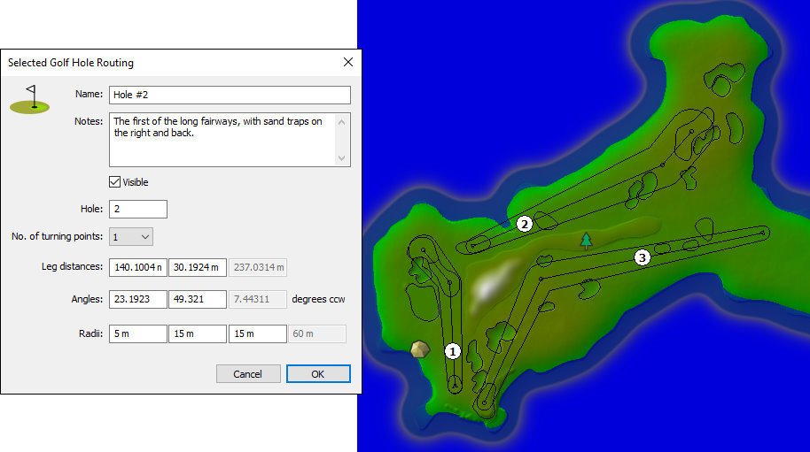
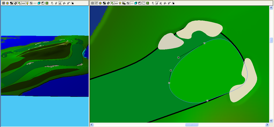
Golf Course Design
"Leveller is intuitive for golf course design; it's like Photoshop for topography.
Working with a heightfield using brush strokes in 3D allows nuanced sculpting of the intended surface. Live contour lines provide the ground truth of slope and elevation, while live cut and fill numerics help achieve desired material gains."
— Jeremy Lavaulx, Design Architect

Prototyping golf courses with the sandbox paradigm makes work an intuitive breeze. If you have a scan of the original terrain, Leveller will dynamically compute cut and fill volumes, and you can view cross sections of any arbitrary path to see slope differences. For those needing contour lines, Leveller can show them in realtime with any spacing, and elevation labels can be placed anywhere. Slope maps make green speeds easy to determine, while curvature maps identify sharp slope changes.
The raytracer includes common scenery objects such as flagsticks, grass, rocks, flowering plants, and deciduous/coniferous/palm trees. The texture library lets you make textures for bunkers, greens, roughs, water hazards, etc. Vector shapes let you precisely define texture splats and distribute objects, and easily reshape/reposition them if needed.
Create flyover animations with custom camera paths.
Use hole routing shapes to simplify planning and layout of fairways.
“A powerful 3D terrain editor.”
— Laura Seabroook, OpenSimulator user
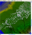
Vector Shapes
You can mark up the heightfield with polyline and spline shapes, as a visualization aid or as a modeling assist.
Use vector shapes to annotate, to add local texture detail, and to easily fill areas with objects. Illustrator-style controls let you easily create markers (points), lines, polygons, circles and arbitrary curves. You can also obtain raster selection masks from vector shapes for precision modeling. Elevated shapes let you work with contour lines and quickly create heightfield formations. Import shapes from GDAL-supported formats and Adobe Illustrator or SVG, and export to DXF, Illustrator, and to SVG.
- Tools similar to Adobe Illustrator for easy learning.

- Compound paths supported; imported shapefile multipolygons use them.
- Extract heightfield selection mask from selected shapes.
- Assign fill color/opacity, stroke color/opacity, and stroke width to selected shapes.
- Distribute 3D objects within a shape's fill and/or along its stroke.
- Feather shape content to smoothly merge with underlying ground color or other shapes.
- Assign optional elevation to selected shapes.
- Extract convex hull from selected shapes (e.g., contour line rasterization).
- Extract contour lines from heightfield into elevated polyline shapes.
- Import vector shapes from SVG, Illustrator and through GDAL (DXF, ESRI, TIGER/LINE, etc.).
- Make heightfield formations from elevated shapes.

- Interpolate shapes, and make heightfield formations from elevated interpolated shapes.
- Export vector shapes to Illustrator, DXF, and SVG.
- Cut, join, and align shape points.
- Paste in front/back, send shapes forward/backward or to the front/back.
- Annotate shapes with optional names and text notes.
- Tesselate, simplify, and insert points into selected shapes.
- Use shapes to create smooth flyover animation camera flight and look-at paths.
- View shapes in high resolution with auto-LOD renderer or when raytracing.


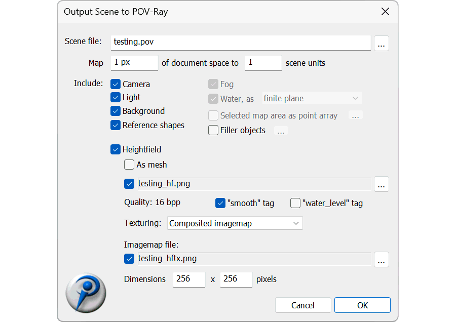
“The POV-Ray options are excellent.”
— Cees van der Mark, artist
3D Objects
Arbitrary 3D objects can be placed by importing Autodesk FBX scene files (or DXF, Alias OBJ, Collada DAE), and then moved, named, and given an overall color. They're visible while modeling, and intended as reference geometry to position edits. Quads and n-gons are assumed to be convex.
Leveller's raytracer has its own object system, where predefined objects can be placed and shader-based ground textures can be applied, in areas defined by shape fills or strokes.
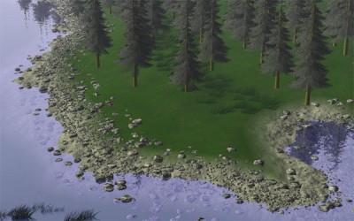
- Object types include deciduous/coniferous/palm trees, plants, rocks, flagpoles, grass, and general-purpose billboards.
- Ground texture shaders include color, bumpmapping, imagemapping, gloss, and reflection.
- Megatexture builds itself automatically, and tile size is user-definable.
- Place numerous objects using filler definitions, allowing easy reuse of distribution patterns and transforms.
- Place individual "landmark" objects using markers.
- Objects can be culled by slope, elevation, water, and view frustum.
- Objects have realworld size, automatically resizing and redistributing them if heightfield is resampled or if its coordinate system changes.
- Drape textures can be applied as-is or blended with the elevation colormap.
- Drape textures can be arbitrarily scaled, rotated, and/or tiled, and auto-placed if georeferenced.
Supported File Formats
Leveller can import/export a variety of file formats. Note: the data tables are wide so for best viewing, mobile device users should prefer a landscape orientation.
Signage/CNC Usage/3D Printing
Many people use Leveller for signage and CNC work. Our STL plug-in, for example, exports standard StereoLithography files (solid or surface-only, text or binary) that can drive production equipment.

While Leveller is mostly used by people in the landscape, landsite, and terrain illustration industry, the underlying digital sandbox mechanism lends itself very well to the sculpting of any 3D surface.
“There are so many things you can do with this awesome program.”
— redrider197, posted on TwistedDIRT forum